

L-sections and cross-sections surveys are important components of land surveying that provide detailed information about the vertical profile and terrain of a specific area. These surveys are typically conducted along a linear path, such as a road, pipeline, or drainage channel, and involve the measurement and representation of the ground surface and its features.
Both L-sections and cross-sections surveys are essential in engineering design, construction planning, and infrastructure development. They provide valuable insights into the existing ground conditions, enable accurate calculations for earthwork quantities, assist in designing slopes and drainage systems, and help ensure the overall feasibility and safety of the project.
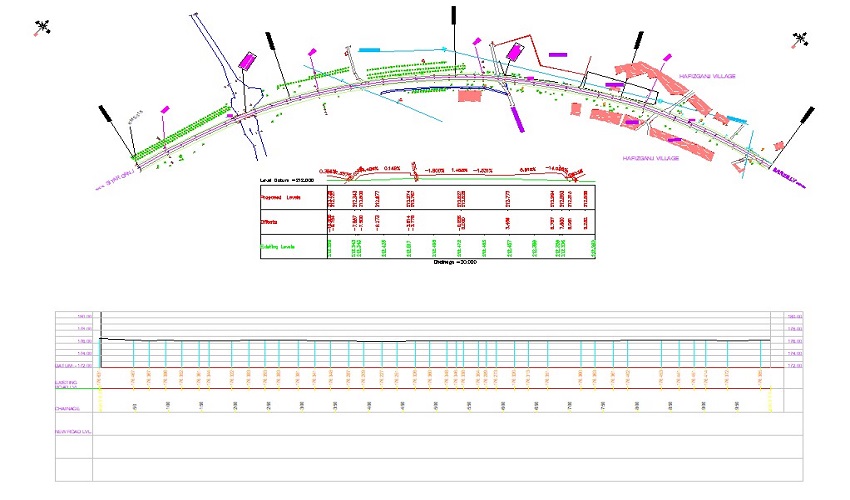
An L-section survey involves the measurement and depiction of the vertical profile of the ground along a specific line or alignment. The surveyor takes measurements at regular intervals, typically at specific chainage points, to determine the ground level, natural and man-made features, and changes in elevation along the surveyed line. The resulting data is presented in the form of an L-shaped graphical representation, showing the ground profile, typically with the chainage or stationing marked on the horizontal axis and the corresponding elevations on the vertical axis. L-sections are commonly used in road construction, pipeline installation, and drainage projects to analyze slopes, identify cut and fill requirements, and plan for proper drainage.
A cross-section survey involves the measurement and representation of the ground profile perpendicular to the alignment or path of interest. Surveyors take measurements at regular intervals, typically at designated cross-section stations, by measuring the ground elevation and other features such as road width, ditches, embankments, and existing structures. These measurements are taken across the alignment to provide a comprehensive understanding of the land's terrain and topography. Cross-sections are often depicted as graphical representations with the horizontal axis representing the alignment or path and the vertical axis showing the ground elevations at specific stations. Cross-section surveys are crucial in road design, drainage planning, and infrastructure projects as they provide valuable information for designing slopes, analyzing earthwork quantities, and determining the suitability and impact of the project on the existing terrain.
We specializes in conducting L-sections and cross-sections surveys, utilizing advanced surveying equipment and techniques to provide accurate and detailed data. Contact us today to discuss your surveying needs, and our experienced team will be ready to assist you with professional survey services.
Get answers and advice from people you want it from.